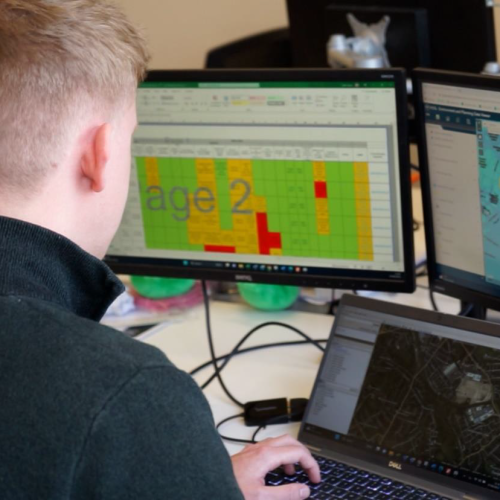
Our geomatics team calibrated the Geo7x Series handheld GPS device to record the depth detected automatically into a pre-designed form on the Geo 7x, which increased efficiency on an otherwise lengthy task.
The project
- To survey 270km of HP Gas pipelines across various land types
- Take depth recordings every 50m to meet the client’s obligation to monitor ground cover over the apparatus
- Recordings required every 5m in areas where reduced cover was identified
- Recordings required to be fed back to the client for record-keeping within tight timeframes
How we did it
This project was completed using our CAT & Genny GPS equipment.
Our geomatics team calibrated the Geo7x Series handheld GPS device to record the depth detected automatically in to a pre-designed form on the Geo 7x, which increased efficiency on an otherwise lengthy task. The Geo 7x and the CAT & Genny devices were linked via Bluetooth, so once we established a reading it would be a simple case of taking the reading on the CAT & Genny which would automatically send the reading to the Geo 7x and fill out the pre-designed form, cutting out any manual inputting of data and increasing our efficiency.
We also used various mobile apps to assist in providing the most efficient method of collecting data whilst also looking out for our surveyors’ personal safety:
- We used a WhatsApp group so that we could share our live location for the whole day and keep in touch easily with colleagues back in the office.
- We used our historic data showing all pipelines that required to be walked with land use from the previous year, allowing us to plan the day’s work in manageable sections
- We used the CarryMap app to show areas of land taken from our bespoke Web-GIS system, MapThat, to show any landowners with specific requirements regarding access or that needed to be notified before surveys took place.
Our Achievements
Dalcour Maclaren produced a highly accurate and proficient set of data, showing the precise location of the pipelines and every individual point recorded and colour coded using a RAG status, with the depth measurement recorded as an attribute, allowing the client to see the areas that require attention.
To find out more about the Geomatics expertise we have to offer, please contact [email protected]
Sector
Power
Location
East Anglia
How we helped
Gas Pipe Linewalking
Get in touch

Tim Donoyou
Associate Director
Related Case Studies


Explore our Expertise
With our single focus on utilities and infrastructure, we anticipate our clients’ needs and provide tailored and effective solutions.